


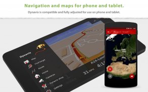
Dynavix Navigation & Cameras
توضیحات Dynavix Navigation & Cameras
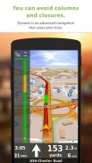
+ ناوبری GPS آفلاین رایگان برای اندروید با قابلیت خودکار اندروید.
+ به روز رسانی رایگان داده های نقشه مادام العمر چندین بار در سال. نقشه ها در دستگاه شما ذخیره می شوند و در هر زمان و هر مکان در دسترس هستند.
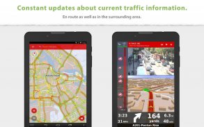
+ دوربینهای ترافیک بیدرنگ به راهنمایی مسیر کمک میکنند.
________________________________________________
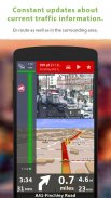
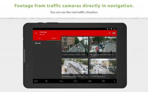
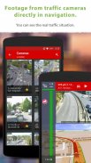
عکسهای فوری از دوربینهای ترافیک آنلاین نزدیک مسیر برنامهریزیشده:
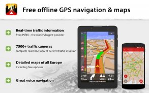
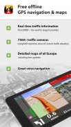
فقط Dynavix به شما امکان میدهد دادههای دوربینهای ترافیک واقع در اطراف مسیر محاسبهشده را مشاهده کنید. علاوه بر این، Dynavix به شما امکان می دهد لیست های سفارشی دوربین ها، مشاهده داده های دوربین ها در نقشه و سایر ویژگی ها را ایجاد کنید. Dynavix در حال حاضر از دسترسی به بیش از 7500 دوربین ترافیک در سراسر اروپا پشتیبانی می کند
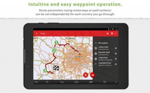
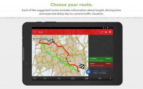
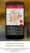
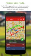
برنامه ریزی پیشرفته مسیر با استفاده از ایستگاه های بین راه:
Dynavix جدید همچنین به طور قابل توجهی برنامه ریزی مسیر را با استفاده از ایستگاه های بین راهی بهبود می بخشد. اکنون برنامه ریزی بسیار واضح است و برای استفاده در تلفن های همراه و تبلت ها تطبیق داده شده است
نقشه های دقیق با کیفیت بالا:
New Dynavix از داده های OpenStreetMap استفاده می کند. ما معتقدیم قدرت جامعه بین المللی و رویه فعلی نشان می دهد که OpenStreetMap بسیار دقیق است و اغلب بهتر از نقشه های ارائه دهندگان دیگر است.
عملکردهای اصلی Dynavix:
• ناوبری صوتی آفلاین گام به گام
• نماهایی از دوربین های ترافیک آنلاین در نزدیکی مسیر برنامه ریزی شده
• به روز رسانی نقشه رایگان طول عمر چندین بار در سال
• اتصال خودکار اندروید
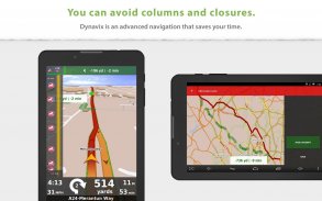
• برنامه ریزی مسیر پیشرفته با استفاده از ایستگاه های بین راهی با امکان اجتناب از عوارض جاده ای در کشورهای خاص یا در طول کل مسیر
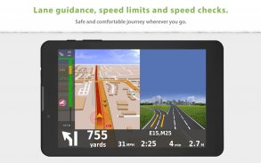
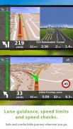
• برچسب های دستیار خط و بزرگراه
• جستجوی آدرس تمام متن
• مسیرهای جایگزین
• پشتیبانی از دستورات صوتی از طریق هندزفری بلوتوث (حالت رسانه یا تماس تلفنی)
• آمار سفر با امکان صادرات به *.csv
• پایگاه داده بزرگ از نقاط مورد علاقه
• نمای نقشه 2 بعدی / 3 بعدی
• اطلاعیه بررسی سرعت (با امکان وارد کردن رادارهای پایگاه داده جامعه)
• هشدار محدودیت سرعت
• ناوبری عابر پیاده
• طیف گسترده ای از گزینه های نمایش شخصی سازی
نقشهها (ذخیره شده در حافظه دستگاه):
اروپا
آلبانی، آندورا، بلاروس، بوسنی و هرزگوین، بلغارستان، کرواسی، جمهوری چک، اتریش، بلژیک، دانمارک، استونی، فنلاند، فرانسه، آلمان، جبل الطارق، یونان، مجارستان، ایتالیا، ایرلند، لتونی، لیختن اشتاین، لیتوانی، لوکزامبورگ، مالت , مقدونیه, مونته نگرو, موناکو, هلند, نروژ, اسلواکی, اسلوونی, اسپانیا, لهستان پرتغال, رومانی, سان مارینو, صربستان, سوئد, سوئیس, ترکیه, انگلستان, شهر واتیکان
اطلاعات ترافیک در کشورهای زیر موجود است:
جمهوری چک، بلژیک، هلند، آلمان، سوئد، انگلستان
آمریکای شمالی
ایالات متحده آمریکا، کانادا
________________________________________________
برای اطلاعات بیشتر به وب سایت ما www.dynavix.com مراجعه کنید
اگر ناوبری Dynavix را دوست دارید، توصیه می کنیم حداقل یک بررسی کوتاه بنویسید
یادداشت:
• ناوبری می تواند به طور چشمگیری عمر باتری را حتی در حال اجرا در پس زمینه کاهش دهد. هنگام استفاده از ناوبری، مطمئن شوید که تلفن را به شارژر متصل نگه دارید.
• اتصال اینترنت برای استفاده از اطلاعات ترافیک بلادرنگ مورد نیاز است.
Dynavix Navigation & Cameras - اطلاعات APK
نسخه APK: 6.6.29حزمة: com.dynavix.navigationآخرین نسخه Dynavix Navigation & Cameras
سایر نسخهها


اپلیکیشنها در دسته مشابه


